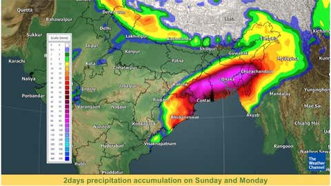
Rainfall accumulation forecast for Sunday and Monday.
(TWC Met Team)Sunday, December 5: After pouring heavy rains across the coastal regions of Andhra Pradesh and Odisha, the remnant of cyclonic storm Jawad is set to mark its presence over parts of east and northeast India—before eventually fizzling out. Substantiation rainfall activity is set to batter Gangetic West Bengal and surrounding states due to the passing over the storm via the regions on Sunday and Monday.
Remnants of cyclonic storm Jawad lies over the northwest west-central Bay of Bengal as a deep depression on Sunday morning. The system is likely to move northeastward along the Odisha coast on Sunday and weaken into a low-pressure area over the northwest Bay of Bengal near the north Odisha coast by Sunday night.
The depression is forecast to produce fairly widespread to widespread rain with lightning over eastern and northeastern India on Sunday and Monday. Heavy rains are likely over isolated places of north Odisha, West Bengal, Assam, Meghalaya, Mizoram and Tripura on Sunday and Monday.
Tracking the movement of this system, the IMD highlights that the system has reached very close to the Odisha coast at 70 km from Puri. Subsequently, it will move towards the West Bengal coast and weaken into a well-marked low-pressure system by Sunday midnight.
An orange alert has been issued over Gangetic West Bengal and Odisha for Sunday, pertaining to these rough weather conditions. This alert by IMD instructs people to ‘be prepared’ on inclement weather conditions.
The rain-bearing system will continue to dump light to moderate rainfall intensity at most places of Gangetic West Bengal. Meanwhile, some isolated places may also experience heavy to very heavy rainfall on December 5. In addition, the West Bengal coast is also set to brace for strong winds gusting at the speed of 35-45 kmph to 55 kmph on Sunday.
Districts, namely, North 24 Parganas, South 24 Parganas, East & West Midnapore, Jhargram, Howrah, Kolkata, Hooghly, Birbhum, Bankura, Nadia, Murshidabad, East Bardhaman and West Bardhaman are in for heavy to very heavy rain (7-20 cm) on Sunday.
The IMD has strictly advised fishers not to venture into the coasts as the sea conditions are noted to be rough to very rough during the next 24 hours—around the coasts of north Andhra Pradesh, Odisha and West Bengal.
Following this day, the alert has been downgraded to a ‘yellow watch’ over the region, thus advising residents to only ‘be updated’ on the weather situation. Therefore, the coverage of heavy rain is expected only in a few districts, including North Parganas, South 24 Parganas, Nadia and Murshidabad, on Monday.
After this, the remnants of the cyclonic storm will impact Northeast India on its path, taking into the grip south Assam, Meghalaya, Mizoram and Tripura. However, the intensity is noted to be less as light to moderate rainfall has been forecast at many places. Heavy rainfall is expected only at some isolated places of the states mentioned above.
In between October 1 to December 5, the places of East and Northeast India has the following amount of rains: Assam (124 mm), Meghalaya (203 mm), Mizoram (128 mm), Tripura (117 mm) and West Bengal (233 mm).
**
For weather, science, and COVID-19 updates on the go, download The Weather Channel App (on Android and iOS store). It's free!
"heavy" - Google News
December 05, 2021 at 05:49PM
https://ift.tt/31nghJh
Cyclone Jawad Dumps Heavy Rain Over East Coast; Orange Alert Remains Over West Bengal, Odisha Even as Storm Fizzles Out | The Weather Channel - Articles from The Weather Channel | weather.com - The Weather Channel
"heavy" - Google News
https://ift.tt/35FbxvS
https://ift.tt/3c3RoCk
heavy
Bagikan Berita Ini


0 Response to "Cyclone Jawad Dumps Heavy Rain Over East Coast; Orange Alert Remains Over West Bengal, Odisha Even as Storm Fizzles Out | The Weather Channel - Articles from The Weather Channel | weather.com - The Weather Channel"
Post a Comment