A pretty — but pretty cold — weekend will be followed by a multi-day nor’easter.
Low temperatures will remain in the single digits again this morning in Southeastern New England, making it the first back-to-back single-digit days since Jan. 30 and Jan. 31, 2019.
But at least the wind is relaxing as we warm up to close to 20 degrees in Southern New England this afternoon.
There’s plenty of sunshine except for in the northern mountains, where we have clouds and flurries, and on outer Cape Cod also with clouds and flurries.
High pressure moves right over us tonight, making for a big, beautiful, bright moon and the planets and stars should look brilliant with a clean dry air mass.
Once again you want to layer up if you’re going outdoors for a walk, with temperatures falling to the single digits south and well below zero north for Sunday morning.
The City of Boston opened about a dozen warming centers this weekend to get people out of the cold, and that's critical because this kind of deep freeze can quickly turn into a medical emergency for anyone.
“I love the chill. I’m okay with the chill,” said Newton resident Ron Ribitzky, who stood in line at Harvey's Ace Hardware's outdoor checkout counter in Needham so he could grab ice melt ahead of the nor'easter.
“It’s New England in the winter, so I’m not surprised,” said Jessica Tolman, of Needham.
The wind chill couldn't scare Mia Daoust away from her afternoon run.
“The first two miles were pretty cold, but now I’m warming up,” she said.
Daoust runs in this cold weather in light clothing, and she says it's more enjoyable than it looks.
“I think it’s kind of nice while running. You don’t get too hot, and it’s easier to breathe,” she said.
But this kind of deep freeze can quickly turn into a medical emergency for anyone, according to Dr. Ali Raja of Massachusetts General Hospital.
“When it gets this cold, it’s surprising how fast hypothermia can actually kick in," he said. "Even a few minutes outside without unexposed skin and without enough warm clothing can result in a drop in in your core body temperature.”
The City of Boston opened a dozen heating centers this weekend to help combat the cold. They close each night at 6 p.m.
The bitter cold sent Boston into a deep freeze on Friday with temperatures barely in the double digits.
Weather wise, Sunday looks great, though, with plenty of sunshine and light wind. High temperatures will get to the teens north and 20s south with increasing clouds in the afternoon.
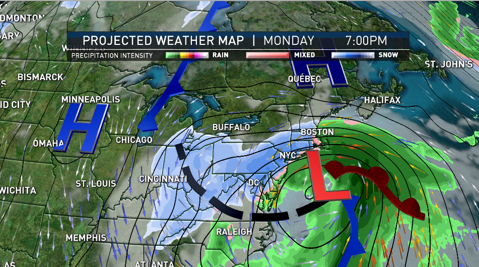
The storm system that dropped 8 feet of snow at Mammoth Mountain in California is crossing the nation and will be on our doorstep Monday morning.
At that time it will be snowing heavily from Philadelphia to New York City, with a wall of moderate to heavy snow easing from south to north in Southern New England.
We probably get a few inches of snow in the first few hours, before changing to rain along the coast near Cape Cod.
For most of central and southern New England it looks like an eight-to-10-hour band of heavy snow later Monday into early Tuesday, so it’s likely an 8-10 inch snowfall — for an early rough estimate.
Low pressure will move from Pennsylvania then re-develop south of Long Island and slowly track to near Nantucket.
An upper level low will stall overhead with several surface low pressure systems rippling from south to north through the Gulf of Maine. That means bands of heavy snow, with rain at the coast Tuesday day and into the evening.
Coastal wind from the east and northeast will gust past 50 miles an hour Monday night and first thing Tuesday. There’s a chance of a lighter wind from the south from Boston to Cape Cod Tuesday with temperatures jumping to near 40 degrees and snow changing to drizzle.

Otherwise, further inland, bands of snow will continue on Tuesday, with the heaviest accumulation at this time in the mountains of Vermont, New Hampshire, and Maine.
There may be a hole in the middle of the precipitation amounts, with lesser amounts in southern Vermont, western Massachusetts, and western New Hampshire. But for much of New England we may end up with a 10-20 inch snowfall — where it stays all snow.
Wind will come back from the north Tuesday night, with perhaps icy conditions returning all the way to the southern and eastern coast line. Wednesday is likely a cold gray day before a little sunshine Thursday. Thursday night a warm front will bring a mixture of rain and snow followed by a big warm-up late in the week with heavy rain showers possible as we head toward next weekend.
It’s a very busy First Alert 10-day forecast.
"heavy" - Google News
January 31, 2021 at 05:00AM
https://ift.tt/39yCG7F
First Alert: Multi-Day Nor'easter Bringing Heavy Snow to Region Monday Into Tuesday - NBC10 Boston
"heavy" - Google News
https://ift.tt/35FbxvS
https://ift.tt/3c3RoCk
heavy
Bagikan Berita Ini


0 Response to "First Alert: Multi-Day Nor'easter Bringing Heavy Snow to Region Monday Into Tuesday - NBC10 Boston"
Post a Comment