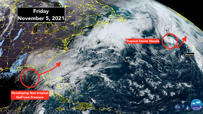
A low-pressure system is strengthening over the eastern Gulf of Mexico. During hurricane season, we would be worried about that. As we have often seen, tropical systems can organize and intensify rapidly over the warm waters of the Gulf. But that’s not a concern with this system.
Today’s low and its associated upper-level disturbance are going to produce heavy rain over parts of the peninsula today, but the energy for this storm is not coming from the Gulf water. The low pressure is part of a long frontal system that divides the cool fall air over North Florida and the eastern U.S. and humid tropical air over South Florida.
The winds are from the north in North Florida and from the south over the southern peninsula and the Keys. The air is colliding along the front and getting wrapped into the low. The energy to power the system comes from the contrasting air masses that are colliding along the front.
Meteorologists use the word baroclinic to describe this process of energizing a storm. A strong jet stream is part of the process as well, which simultaneously prohibits any tropical systems from developing. One of the things we look for to see that the hurricane season has ended is that the jet stream dips south across the Gulf and Caribbean, as it is now.
Sometimes a non-tropical low-pressure system sits over the warm water of the Atlantic long enough that it separates from its associated fronts and uses tropical warm-water processes for energy. This is what happened with now-Tropical Storm Wanda. Recall that it started life as a nor’easter off New England and eventually evolved into a quasi-tropical then fully tropical system.
Wanda is still drifting around in the middle of the Atlantic. The consensus forecast is that it will lollygag around for another couple of days, and then get scooped up into the North Atlantic where it will remerge with a front.
The only question is how close it comes to the westernmost Azores when it’s scooped. Some of the computer forecast models indicate that they will feel the storm when it rushes by about Sunday.
When Wanda is off the board, the chances are that we are done with hurricane season, but that’s not 100%. There’s no way to predict when another non-tropical system gets stranded over the still warm-enough ocean, though the odds lower every day.
No matter what might or might not happen over the Atlantic, today’s Gulf low-pressure system will power a strong cold front, which will sweep the tropical air out of Florida. It will finally feel like fall over the entire state by Sunday.
To see the latest forecast information heading into the weekend, CLICK HERE.
"heavy" - Google News
November 05, 2021 at 08:43PM
https://ift.tt/3o1f5Cr
Today's heavy rain is an indication the season has changed - WPLG Local 10
"heavy" - Google News
https://ift.tt/35FbxvS
https://ift.tt/3c3RoCk
heavy
Bagikan Berita Ini


0 Response to "Today's heavy rain is an indication the season has changed - WPLG Local 10"
Post a Comment