SEATTLE - Happy Wednesday!
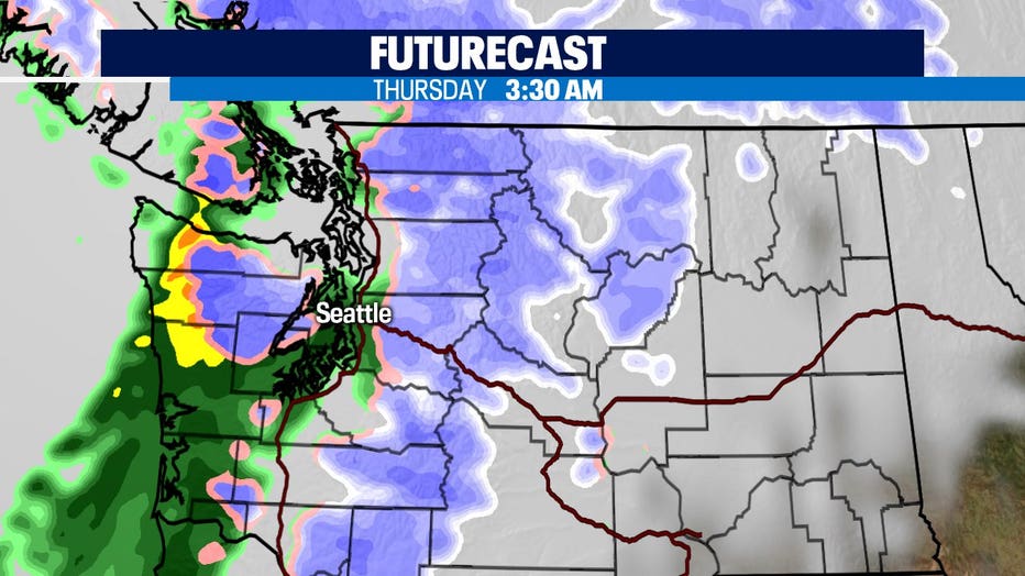
The next system is on the way now and this weather maker will deliver rain, gusty winds, and heavy mountain snow. The Q13 News Weather Team is issuing a "Weather Alert Day" due to the incoming conditions. Expect heavy rain to start along the coast overnight and push inland through the early morning hours of Thursday. The bulk of the rain will wrap up for the metro area during the morning commute. Winds will start to pick up as well.
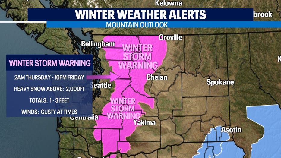
As the system travels into the Cascades heavy snow will begin to fall right away. We're not just talking 6-12", but instead possibly 1-3 feet between Thursday and Friday. As you can imagine WSDot crews will have their work cut out for them trying to keep the passes safe to drive over. Expect difficult travel at times with potential closures for clearing and avalanche control work.
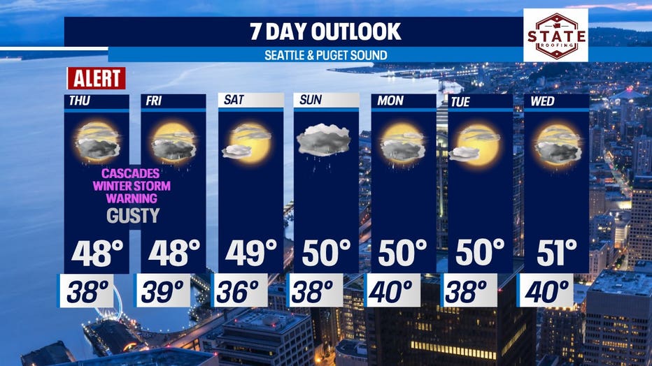
Weather Alert Day for Thursday, Friday
Expect a Winter Alert for mountain passes, high winds and rain in the lowlands for Thursday and Friday. Q13's Lisa Villegas details the conditions and what to expect this week.
A "Winter Storm Warning" goes into effect 2 a.m. Thursday lasting through Friday night for the areas in pink below. Please plan accordingly when driving through the Cascades. Winds will gust at times between 25-35mph at pass level with stronger bursts 45-65 mph for the higher elevations. These gusts will cause poor visibility with blowing and drifting snow at times.
Advertisement
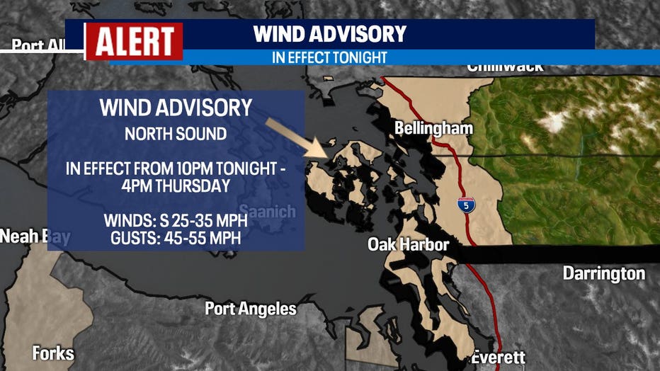
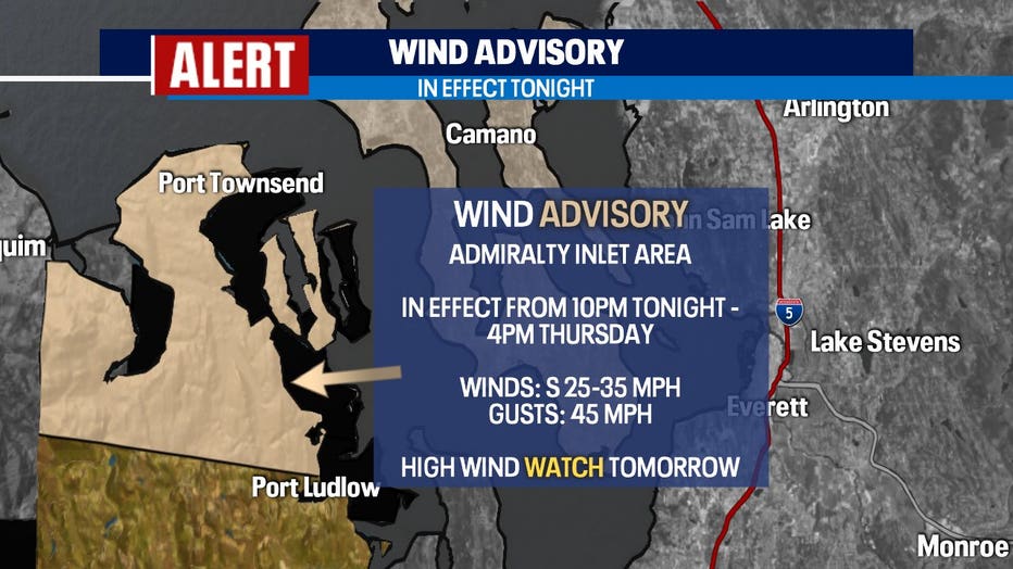
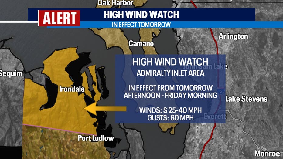
There are also "Wind Alerts" for the lowlands too. Over the next 24 hours several areas will be under a "Wind Advisory" and/or a "High Wind Watch". Winds will get pretty gusty at times out of the south.

By Thursday afternoon rain will taper off some, but there is a chance for the lowlands to see a thunderstorm or two pop up around the King/Snohomish county line. Mountain snow continues to fall across the Cascades and parts of Eastern WA.
Showers will become spotty Friday for the lowlands and start to wrap up overnight into Saturday. Winds will continue to gust around the region throughout Friday while mountain snow piles up through Saturday morning. Most of Saturday looks dry! Highs land in the upper 40s to near 50. Rain returns late Saturday into early Sunday with a little more mountain snow falling for the North and Central Cascades. Snow levels will sit between 1,000-2,000ft over the next seven days.
Monday - Wednesday next week is looking mainly dry with skies seeing mostly to partly cloudy conditions, but there are a few areas where showers sneak back into the forecast. Overall, pretty quiet compared to our active weather over the weekend.
Have a great night! ~Erin Mayovsky, Q13 Forecaster
Q13 WEATHER RESOURCES:
DOWNLOAD: Q13 Weather and News Apps
WATCH: Forecast and Radar
READ: Closures and Delays
CHECK: Latest Weather Alerts and Live Traffic Map
INTERACT: Submit your Weather Photo
FOLLOW: Lisa Villegas, MJ McDermott, Tim Joyce, Erin Mayovsky and Grace Lim
"heavy" - Google News
February 25, 2021 at 12:20PM
https://ift.tt/2ZQuNod
Weather Alert Day Thursday due to gusty winds and heavy mountain snow. - Q13 FOX (Seattle)
"heavy" - Google News
https://ift.tt/35FbxvS
https://ift.tt/3c3RoCk
heavy
Bagikan Berita Ini


0 Response to "Weather Alert Day Thursday due to gusty winds and heavy mountain snow. - Q13 FOX (Seattle)"
Post a Comment