Today’s Forecast:
We're going to see a very active afternoon and evening across southern Colorado as strong to severe storms move out of the mountains and across the plains.
Light rain overnight will continue through the early morning in areas like Fremont and El Paso Counties, but most of the region will start cloudy, foggy, and cool.
Storms will develop this afternoon over the southern mountains around and just after lunch, growing stronger through the mid-afternoon to the end of the day. Storms will move east across the plains overnight, spreading out with heavy rain and a few severe threats.

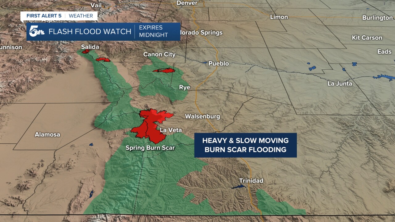
Flooding is one of our largest concerns today, mainly in and around the Wet and Sangre De Cristo Mountains. Slow-moving storms with heavy rain could lead to flooding in low-lying areas, but the burn scars are the most prone areas.
The Spring burn scar is especially concerning today with the amount of rain we see in the forecast models from the afternoon through the evening hours. Everyone living around La Veta, Cuchara, and even Walsenburg should be on alert for any flood evacuations today and tonight.

Severe threats are pretty widespread today, but we can narrow things down here.
Severe threats for the Sangres and Wet Mountains include hail and flooding. Severe threats from Pueblo to Trinidad on I-25 involve some localized flooding as well as large hail 1-2" in diameter. Storms east of I-25 include large hail and isolated landspout tornadoes, but the tornado threat would diminish pretty quickly in the evening.
COLORADO SPRINGS: High: 62; Low: 43. A few showers in the morning with rain returning late today through tonight. Small hail and heavy rain are the main storm threats today in the city, but isolated severe storms are possible south closer to Pueblo on I-25.
PUEBLO: High: 67; Low: 46. We'll see a cloudy and dry start to the day with a very stormy and wet finish. Storms will move into Pueblo late today and continue through the overnight hours. Severe weather is possible in Pueblo today with large 1-2" hail and street flooding as our main storm threats.
CANON CITY: High: 64; Low: 49. Heavy rain and storms are back in the afternoon today but severe weather is not likely. We could see small hail and lightning, but storms should stay under severe criteria over the city.
WOODLAND PARK: High: 52; Low: 37. Afternoon rain and thunderstorms are possible today with lightning and small hail being our biggest threats.
TRI-LAKES: High: 50s; Low: 40s. Cloudy and chilly today with storms moving in late today through tonight, but severe weather is not expected. There could be small hail and lightning, but storms should stay under severe criteria.
PLAINS: High: 60s; Low: 40s. We'll see a very active day across the plains with storms leaving the southern mountains and pushing east across I-25 in the afternoon and evening. We'll see widespread heavy rain with lightning and large hail as the biggest storm threats. We can't rule out an isolated landspout tornado anywhere south of Highway 50 from late today through the evening.
WALSENBURG/TRINIDAD: High: 60s; Low: 40s. Heavy rain and flooding with 1 inch hail are the biggest storm concerns for the mountain west of I-25 with large hail and the small chance for an isolated landspout tornado along and east of the interstate. Large hail and strong winds are the primary storm threats for I-25 from Walsenburg to Trinidad this afternoon.
MOUNTAINS: High: 40s; Low: 30s. We'll see a threat for strong to severe storms with hail and flooding as the biggest threats over the mountains. Flooding in particular is of concern in the southern Sangres and Wet Mountains, with the Spring Burn Scar primed for a flash flood event. Prepare early today if you live in and around an area prone to flooding.
Extended Outlook:
We'll see more scattered and isolated storms on Tuesday and Wednesday, starting over the mountains then moving east to the plains. A few storms could be strong over the next two days, but severe potential, in particular, is pretty low.
We will see a warmer and dry Thursday with a return of scattered and isolated storms on Friday and Saturday.
KOAA News5 on your time, streaming on your Roku, FireTV, AppleTV and AndroidTV.
News5 App | First Alert 5 Weather App | Youtube | Facebook | Instagram | Twitter
"heavy" - Google News
May 17, 2021 at 07:13PM
https://ift.tt/3wchU67
Heavy rain with thunderstorms this afternoon and evening - KOAA.com Colorado Springs and Pueblo News
"heavy" - Google News
https://ift.tt/35FbxvS
https://ift.tt/3c3RoCk
heavy
Bagikan Berita Ini


0 Response to "Heavy rain with thunderstorms this afternoon and evening - KOAA.com Colorado Springs and Pueblo News"
Post a Comment