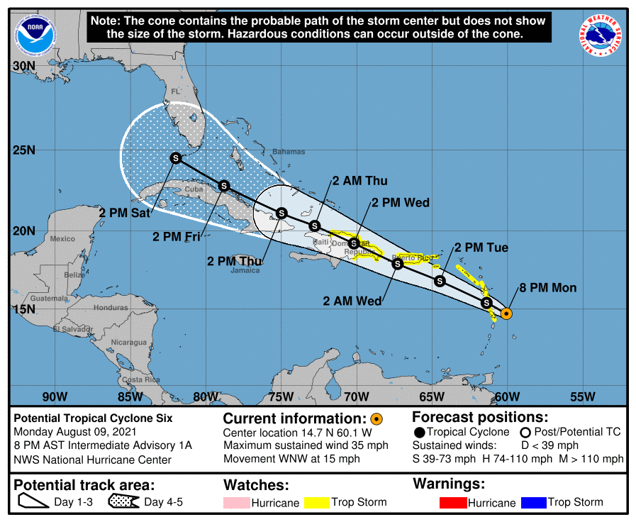
SUMMARY OF 800 PM AST…0000 UTC…INFORMATION
LOCATION…14.7N 60.1W
ABOUT 90 MI…145 KM ESE OF DOMINICA
ABOUT 135 MI…220 KM SE OF GUADELOUPE
MAXIMUM SUSTAINED WINDS…35 MPH…55 KM/H
PRESENT MOVEMENT…WNW OR 290 DEGREES AT 15 MPH…24 KM/H
MINIMUM CENTRAL PRESSURE…1010 MB…29.83 INCHES
WATCHES AND WARNINGS
A Tropical Storm Watch is in effect for…
* Martinique and Guadeloupe
* Dominica
* Saba and St. Eustatius
* Puerto Rico, including Culebra and Vieques
* U.S. Virgin Islands
* Dominican Republic on the south coast from Punta Palenque eastward and the entire northern coast to the Dominican Republic/Haiti border.
DISCUSSION AND OUTLOOK
At 800 PM AST (0000 UTC), the disturbance was centered near latitude 14.7 North, longitude 60.1 West. The system is moving toward the west-northwest near 15 mph (24 km/h) and this general motion is expected to continue during the next few days. On the forecast track, the disturbance is expected to move across the southern Leeward Islands later tonight, pass near or over the U.S. Virgin Islands and Puerto Rico late Tuesday and Tuesday night, and be near or over Hispaniola on Wednesday.
Maximum sustained winds are near 35 mph (55 km/h) with higher gusts. Gradual strengthening is forecast during the next day or two, and the disturbance is expected to become a tropical storm overnight.
* Formation chance through 48 hours…high…90 percent.
* Formation chance through 5 days…high…90 percent.
The estimated minimum central pressure based on surface observations is 1010 mb (29.83 inches).
HAZARDS AFFECTING LAND
RAINFALL: The potential tropical cyclone is expected to produce the following rainfall amounts:
Over the Leeward Islands, Virgin Islands, and Puerto Rico…2 to 4 inches, with isolated amounts of 6 inches. This rainfall could lead to flash, urban, and small stream flooding and potential mudslides across the U.S. Virgin Islands and Puerto Rico.
Over the northern Windward Islands…1 to 3 inches.
Over the Dominican Republic…3 to 6 inches.
WIND: Tropical storm conditions are possible within the watch area in the Lesser Antilles later tonight, and are also possible within the watch area in the U.S. Virgin Islands and Puerto Rico beginning Tuesday afternoon. Tropical storm conditions are possible within the watch area in the Dominican Republic beginning early Wednesday.
SURF: Swells generated by the disturbance are affecting portions of the Leeward Islands. These swells are expected to spread across the U.S. Virgin Islands and Puerto Rico on Tuesday and across portions of Hispaniola on Wednesday, and they could cause life-threatening surf and rip current conditions.
"heavy" - Google News
August 10, 2021 at 07:00AM
https://ift.tt/3s5MldB
PTC-6 Nearing the Leeward Islands with Heavy Rains & Gusty Winds Expected There Overnight - alabamawx.com
"heavy" - Google News
https://ift.tt/35FbxvS
https://ift.tt/3c3RoCk
heavy
Bagikan Berita Ini


Related Posts :
 As winter approaches, Utah remains in drought, needing multiple years of heavy snowpack - ABC 4
- Can CNN+ Succeed in a Streaming-Heavy Universe? - TVNewser
- Heavy rain could increase flooding risk in western Washington this week - KING5.com
- Sting Calls Himself a 'Heavy Metal Singer' & His Reasoning Makes Sense - wmgk.com
- Indian government's plan to ban cryptocurrencies leads to heavy selling – investors - WTVB News
0 Response to "PTC-6 Nearing the Leeward Islands with Heavy Rains & Gusty Winds Expected There Overnight - alabamawx.com"
Post a Comment