The D.C. region is on the cusp of a Flash Flood Emergency, a rare occurrence that happens when extremely heavy rains lead to a severe threat to human life.
“This could be the worst flooding in three years,” Storm Team4 Meteorologist Mike Stinneford said.
A Flash Flood Emergency is when “CATASTROPHIC DAMAGE” from flash flooding occurs, the National Weather Service stated.
“Typically, emergency officials are reporting LIFE THREATENING water rises resulting in water rescues/evacuations.”
The National Weather Service has issued a Flash Flood Warning until 12:45 p.m. for northeastern D.C., southeastern Montgomery County and northwestern Prince George’s County.
Flash Flood Warnings are also in effect until 12:15 p.m. for south-central Montgomery County, Arlington County, Northeastern Fairfax County, Alexandria and Falls Church. And, a Flash Flood Watch is in effect for Southern Maryland until 5 p.m.
“We are on the cusp of a Flash Flood Emergency. If heavy rain continues for the next half hour we are going to see a widespread and catastrophic flood event for the District and the close-in suburbs of Virginia and Maryland,” Stinneford said.
The National Weather Service has also issued a flood warning for the larger D.C. area noting heavy rainfall that occurred Friday morning, in addition to anticipated precipitation picked up on the NWS Doppler radar.
“At 755 AM EDT, Doppler radar indicated showers producing heavy rain across the warned area. Between 1 and 1.5 inches of rain have fallen. Additional rainfall amounts of 0.5 to 1.5 inches are possible in the warned area. Flash flooding is ongoing or expected to begin shortly,” the National Weather Service said.
“A Flood Warning is less severe than a Flash Flood Warning,” Stinneford said. “In a Flash Flood Warning, creeks and streams are expected to rise rapidly, and dry areas can be flooded in just minutes. A Flood Warning means that the ground is saturated, and any additional rain could cause creeks and streams to come out of their banks, but the rise of water will not be as rapid as what is seen during a Flash Flood.”
“Drivers and residents are urged to stay away or be swept away. Riverbanks and culverts can become unstable and unsafe,” the weather service warned.
The weather service said scattered to numerous showers are expected throughout the day, and thunderstorms are expected this afternoon. Temperatures during the day will be in the mid 70s to the low 80s, and it will be muggy outside.
The thunderstorms will be producing heavy rainfall of 1 to 2 inches per hour on ground that is already saturated. The rain could result in streams and creeks rising quickly, and storm drains and poor drainage areas becoming overwhelmed.
The heavy rain is expected around the D.C. metro area through 10 a.m., Storm Team4 Meteorologist Briana Bermensolo said.
“Be prepared for what could become treacherous conditions,” Bermensolo said during her 4:18 a.m. live weather forecast on WTOP.
Fredericksburg, Virginia, has already experienced heavy rain. Alexandria and Culpeper also are seeing cells of heavy rain.
“The steadiest rain will come in the first half of the day, but scattered thunderstorms will remain likely until this evening,” Storm Team4 Meteorologist Chuck Bell said.
A Flash Flood Warning issued for northwestern Frederick County Friday morning that changed to a flood warning until 9:30 a.m. has been canceled. The weather service said between 2 and 4 inches of rain had fallen. Additional rainfall may result in swollen creeks.
While the D.C. area enjoyed a brief respite on Thursday from the muggy, unsettled weather, a wave of low pressure slowly crossed through the area early Friday. It will be the ninth day out of the last 10 with rainfall in the D.C. region, Bell said.
Humidity returns just in time for the weekend, creating uncomfortable conditions and the chance of widely scattered or isolated thunderstorms.
“That pattern will continue on into Sunday and Monday with increasing temperatures and sunshine as well as decreasing chances for afternoon storms,” Bell said.
Bell also said to watch for Tropical Storm Henri to become a hurricane within the next 24 hours. The storm is moving 65 miles per hour off the coast of North Carolina and heading northward throughout the weekend. If you plan to go the Maryland or Delaware beaches, Bell said to use extreme caution as powerful rip currents will “be a concern.”
Roads
Heavy rainfall is causing problems across the D.C. region on area roads.
The District of Columbia 911 center reports at least a dozen roads are closed due to flooding, and flash flooding continues to occur.
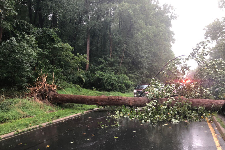
In Arlington, the southbound lanes of the George Washington Parkway are blocked south of Va. 123/Chain Bridge Road. A tree is down. The backup extends “for miles,” WTOP’s Mitch Miller reports. Around 9:28 a.m., northbound lanes opened up.
Traffic backup related to the fallen tree on GW Parkway. pic.twitter.com/hBYQfEHp1m
— Mitchell Miller (@mmillerwtop) August 20, 2021
Fairfax County Police are reporting issues with roads in the following areas:
Sully District Station – Fairfax Station Road at Colchester Road, one lane closed due to a downed tree.
Mason District Station – Woodburn Road at Spicewood Drive, closed due to flooding.
Arlington Boulevard at Prosperity Avenue, closed due to flooding.
3700 block of Prosperity Avenue, closed due to flooding.
Reston District Station –
10100 block of Wendover Drive, closed due to a downed tree.
Hunter Mill at hunter Mill Station, closed due to flooding.
West Springfield District Station –
Burke Road at Heritage Square Drive, closed due to flooding.
Burke Lake Road at Kilkenny Lane, closed due to flooding.
Burke Lake Road at Jerimiah Court, closed due to flooding.
Fair Oaks District Station –
10600 block of Hunters Valley Drive, closed due to a downed tree and wires in the roadway.
Forecast:
Friday: Cloudy and humid. Rain in the morning. Scattered afternoon thunderstorms. Chance of rain 100%. Highs in the upper 70s to low 80s.
Friday Night: Cloudy and humid with occasional showers. Lows in the upper 60s to mid 70s.
Saturday: Partly cloudy but still very humid. Afternoon rain/thunderstorms possible. Highs in the low to mid 80s.
Sunday: Hot and humid, with isolated afternoon thunderstorms. Highs in the mid 80s to 90.
Monday: Mostly sunny, hot and humid. Isolated storms possible. Highs in the upper 80s to low 90s.
Current conditions:
Stay with WTOP for all the latest watches and warnings.
WTOP’s Colleen Kelleher, Anna Gewal and José Umaña contributed to this report.
"heavy" - Google News
August 20, 2021 at 08:30PM
https://ift.tt/3y3YgK0
DC area on cusp of Flash Flood Emergency as heavy rain moves through area - WTOP
"heavy" - Google News
https://ift.tt/35FbxvS
https://ift.tt/3c3RoCk
heavy
Bagikan Berita Ini


0 Response to "DC area on cusp of Flash Flood Emergency as heavy rain moves through area - WTOP"
Post a Comment