SUMMARY OF 4 PM CDT INFORMATION
LOCATION…22.3N 79.6W
ABOUT 15 MI…25 KM SSW OF CAIBARIEN CUBA
ABOUT 210 MI…340 KM SE OF KEY WEST FLORIDA
MAXIMUM SUSTAINED WINDS…35 MPH…55 KM/H
PRESENT MOVEMENT…W OR 280 DEGREES AT 12 MPH…19 KM/H
MINIMUM CENTRAL PRESSURE…1013 MB…29.92 INCHES
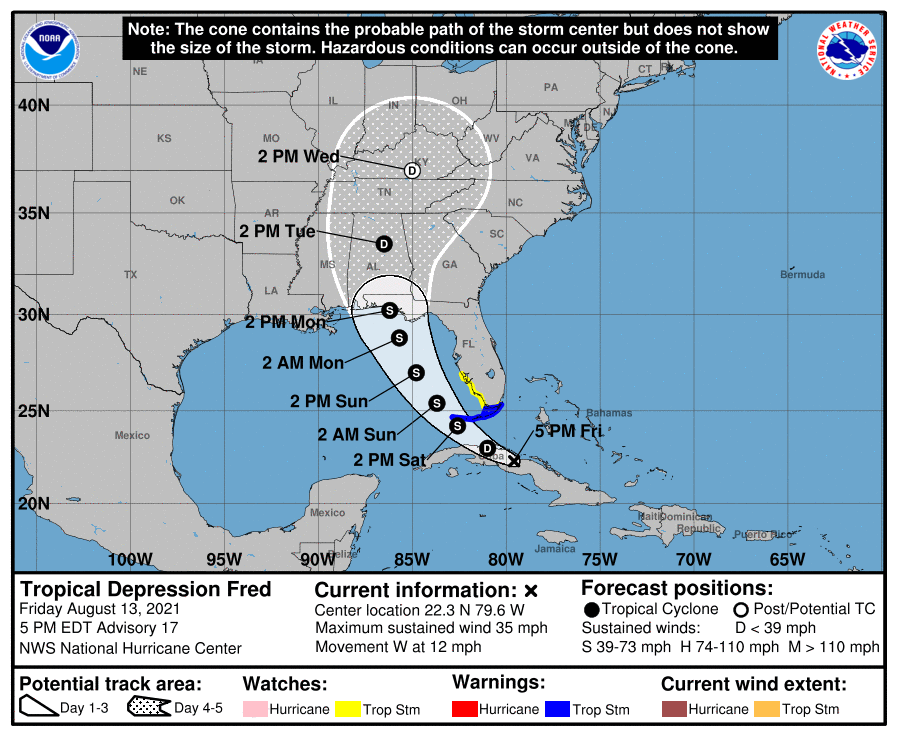
WATCHES AND WARNINGS
A Tropical Storm Warning is in effect for…
* The Florida Keys west of Ocean Reef to the Dry Tortugas
* Florida Bay
A Tropical Storm Watch is in effect for…
* The southwest coast of Florida from Englewood south and east to Ocean Reef
FORECAST DISCUSSION
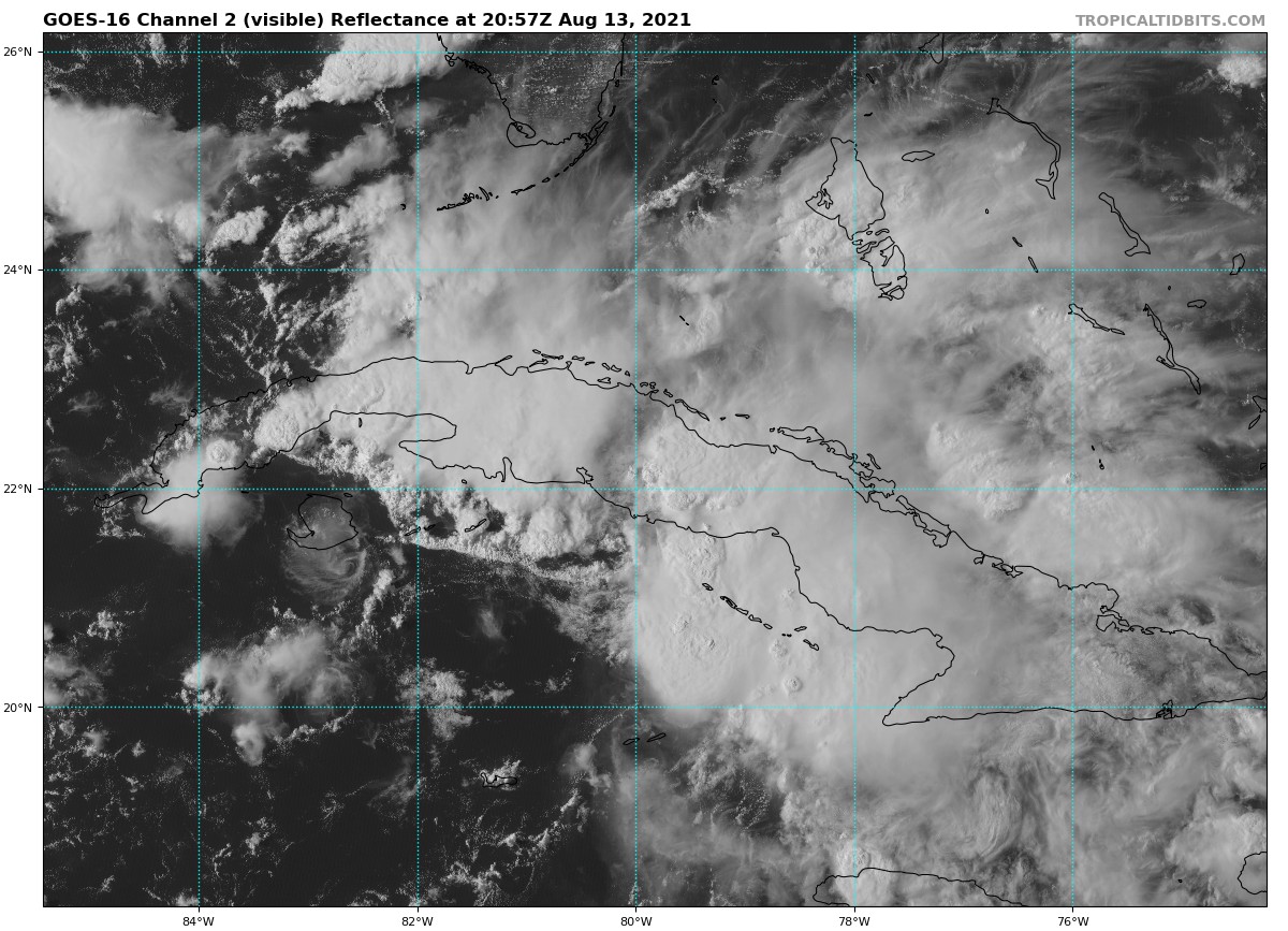
Although there has been a general increase in convection associated with Fred since this morning, the system remains disorganized, with the low-level center moving farther inland over central Cuba. Earlier ASCAT data detected an area of 25-27 kt winds over water to the northeast of the center, and based on that data, the initial intensity is held at 30 kt, which could be a little generous.
Since the previous advisory, Fred has been moving nearly due westward, but the longer-term motion is estimated to be 280/10 kt. The cyclone is nearing the western periphery of a subtropical ridge that is centered over the western Atlantic. This should cause Fred to turn west-northwestward tonight, and then northwestward on Saturday. The latest interpolated guidance that was initialized with the more southward and westward 18Z initial position shows a wider or more gradual northwestward turn, and therefore has shifted significantly westward, especially in the short term. However, the global models fields track the 850-mb vorticity center more along the northern coast of Cuba, and some of those models suggest a center re-formation could occur on Saturday near the north coast of Cuba or over the Straits of Florida. As a result, the first 24-36 hours of the track forecast has been adjusted about a degree westward, but it is not as far west as the trackers, leaving open the possibility that a center re-formation could occur. After that time, the NHC forecast lies along the eastern side of the guidance envelope, in the best agreement with the 12Z GFS. Some additional westward adjustments may be necessary until the track guidance stabilizes. It is worth noting that it isn’t too surprising to see these type of models shifts with a system that remains quite disorganized.
Fred remains within an area of moderate southwesterly vertical wind shear, and the model guidance generally indicates that this shear will continue during the next day or so. Since it will also take time for the system to recover after its passage over Cuba, only gradual strengthening is indicated during the next day or two. After that time, the system could be in a somewhat more favorable environment, and the NHC intensity forecast calls for some strengthening until Fred reaches the northern Gulf Coast, which now doesn’t occur until around 72 hours with the wider turn shown in the track forecast. The NHC intensity forecast lies between the various consensus aids, the statistical guidance, and the HWRF model, which all generally show the system peaking in 60-72 hours. The intensity forecast remains of lower-than-normal confidence due to Fred’s continued interaction with land.
Users are reminded to not focus on the exact forecast track as heavy rainfall, gusty winds, and a chance of tornadoes will extend far to the northeast and east of the center, and those hazards are likely to still affect portions of the Florida peninsula, despite the recent shift in the forecast track.
KEY MESSAGES
1. Today through Monday, heavy rainfall could lead to areal, urban, small stream, and exacerbated river flooding across southern and central Florida into the Big Bend. From Sunday onward, heavy rain and flood impacts could extend into other portions of the Southeast and into the southern and central Appalachians and Piedmont as Fred interacts with a front in that area.
2. Tropical storm conditions are expected in portions of the Florida Keys on Saturday, where a Tropical Storm Warning is in effect.
3. Tropical storm conditions are possible late Saturday and early Sunday across portions of the west coast of Florida in the Tropical Storm Watch area. The risk of tropical storm conditions will spread northward along the Florida west coast and to the Florida Panhandle Sunday and Monday.
Category: Alabama's Weather, ALL POSTS, Severe Weather, Tropical
"heavy" - Google News
August 14, 2021 at 04:14AM
https://ift.tt/3jWtu0y
4 pm Advisory — Heavy Rains from Fred Spreading Over Portions of East and Central Cuba - alabamawx.com
"heavy" - Google News
https://ift.tt/35FbxvS
https://ift.tt/3c3RoCk
heavy
Bagikan Berita Ini


0 Response to "4 pm Advisory — Heavy Rains from Fred Spreading Over Portions of East and Central Cuba - alabamawx.com"
Post a Comment