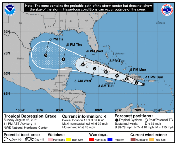
SUMMARY OF 10 PM CDT INFORMATION
LOCATION…17.3N 68.6W
ABOUT 120 MI…190 KM SE OF SANTO DOMINGO, DOMINICAN REPUBLIC
ABOUT 260 MI…415 KM ESE OF PORT AU PRINCE, HAITI
MAXIMUM SUSTAINED WINDS…35 MPH…55 KM/H
PRESENT MOVEMENT…W OR 275 DEGREES AT 15 MPH…24 KM/H
MINIMUM CENTRAL PRESSURE…1011 MB…29.86 INCHES
WATCHES AND WARNINGS
A Tropical Storm Watch is in effect for…
* Entire coast of the Dominican Republic
* Entire coast of Haiti
FORECAST DISCUSSION
An Air Force Reserve Hurricane Hunter Aircraft investigated Grace earlier this evening and found maximum flight level winds just less than 40 kt at 925 mb, which supports Grace’s estimated 30 kt intensity. The plane also found that the depression still has a slightly elongated but closed surface circulation. During the past few hours, satellite imagery has shown a slight increase in convective banding features and associated heavy rain associated with Grace. That activity highlights the primary threat from Grace during the next 24 hours: prolonged heavy rainfall that could lead to flash and urban flooding, along with the potential for mudslides over Puerto Rico and Hispaniola.
The forecast for Grace is incredibly challenging. Imminent interactions with the high terrain of Hispaniola and Cuba could cause Grace to dissipate as soon as Monday evening. However, a track south of Cuba, as shown by recent runs of the GFS and COAMPS-TC, may allow Grace to maintain its tropical cyclone status and possibly even intensify. The HWRF even shows it becoming a hurricane over the western Caribbean, with the caveat that the model has produced several poor forecasts for Grace thus far. Although it is not explicitly forecast, slight intensification is still possible tonight or tomorrow morning before the center of Grace moves inland. After that time, the NHC forecast assumes Grace will continue as a tropical depression through 72 h. Once/if Grace makes it to the western Caribbean Sea and Gulf of Mexico in 3-4 days, it could have an opportunity to reorganize and intensify, and this is again shown in the official intensity forecast. That said, users are encouraged to not focus on the exact track or intensity forecasts at days 4 and 5.
The track guidance has shifted south for this advisory, and generally calls for Grace to move westward to west-northwestward through the forecast period. The official track forecast has been shifted a little south once again, but is north of the most recent multi-model consensus.
KEY MESSAGES
1. Heavy rainfall across Puerto Rico, the Dominican Republic, and Haiti may lead to flash, urban, and small stream flooding, along with the potential for mudslides.
2. Tropical storm conditions are possible over portions of Hispaniola Monday and Monday night.
3. There is a risk of some wind and rainfall impacts across Cuba beginning Tuesday morning, but forecast uncertainty is much higher than usual. Interests there areas should monitor the progress of Grace and updates to the forecast.
"heavy" - Google News
August 16, 2021 at 10:11AM
https://ift.tt/3g5g7dI
10 PM Advisory — Grace Remains a Depression & Causing Heavy Rain in Puerto Rico - alabamawx.com
"heavy" - Google News
https://ift.tt/35FbxvS
https://ift.tt/3c3RoCk
heavy
Bagikan Berita Ini


0 Response to "10 PM Advisory — Grace Remains a Depression & Causing Heavy Rain in Puerto Rico - alabamawx.com"
Post a Comment