The National Weather Service has issued a Flash Flood Watch for East Baton Rouge, West Baton Rouge, Ascension, Assumption, Iberville, East Feliciana, Livingston, Pointe Coupee, St. Helena, St. James, Tangipahoa, and West Feliciana Parishes as well as, Amite, Pike, and Wilkinson Counties from Tuesday morning through Thursday evening.
A FLASH FLOOD WATCH means conditions may develop that lead to flash flooding. Flash flooding is a very dangerous situation. Be on the lookout for threatening weather conditions and listen for later statements and possible warnings. For more on flooding safety, CLICK HERE.

A frontal system will move into the region Tuesday. This front will move very slowly and is expected to stall over southeast Louisiana and coastal Mississippi. The boundary will meander through Wednesday before lifting north as a warm front Thursday morning with a surface low and cold front finally pushing through late Thursday. Multiple rounds of moderate to heavy rain are expected with widespread rainfall amounts of 2 to 5 inches and isolated totals of more than 8 inches are possible. While these areas are difficult to pinpoint until the storms show up on radar, amounts that high would cause some problems. Expect area rivers to rise. While it is too early to forecast crests, many are likely to go above flood stage. Keep in mind, it is common for smaller area rivers to rise above flood stage every year and we should not draw comparisons to past events. Those living on the banks of the Amite, Comite, Tangipahoa and Tickfaw should make the usual preparations.
Tonight: Clouds and moisture will slowly increase. This will cause a muggy feel and low temperatures to stop in the low to mid 60s. Winds will remain out of the southeast at 5-10mph.
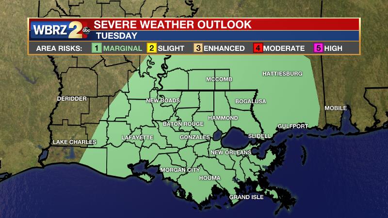
Tuesday: Expect coverage and intensity of showers and thunderstorms to increase through the morning hours. This will mark the first round of action in our area. Any thunderstorms will be capable of heavy rain and be aware that there is a chance for one or two storms to become severe with gusty wind, hail or even an isolated tornado. The Storm Prediction Center has issued a 1/5 "marginal risk" for severe weather. High temperatures will be somewhat limited due to clouds and rain, likely not rising past the mid 70s. Activity will take a breather overnight with low temperatures in the mid 60s.
Wednesday: Another round of activity is expected on Wednesday. While severe weather may not be in the cards, any thunderstorms could still produce very heavy rain. Skies will otherwise be mostly cloudy with highs in the mid 70s. With nighttime temperatures barely into the upper 60s, a punch of rain and thunderstorms is anticipated into Thursday morning.
Thursday: The final day of the unsettled stretch is currently the most uncertain. There several indications that it could be another dual heavy rain and severe weather threat as a low pressure system tracks very close tot eh area followed by cold front that will swipe away the moisture responsible for the heavy rain threat. Once this cold front makes it through, low temperatures will back into the 50s overnight.
Friday and the weekend: The workweek will end on a nice note with mostly sunny skies and highs in the upper 70s. Another frontal system is pegged for the weekend. Right now, an area of showers and thunderstorms is possible late Saturday into early Sunday, but the entire weekend does not look like a washout.
CLICK HERE for your full 7-Day Forecast.
Remember that the WBRZ WX App. is *free* on Apple or Android devices and can be used for breaking weather information, live radar, as well as daily and hourly forecast details. You can also use it to watch live coverage if power or broadcast signal is ever lost. For even more, plug into the WBRZ Weather Team on Twitter and Facebook.
"heavy" - Google News
March 23, 2021 at 04:30AM
https://ift.tt/3f5quhL
Flash Flood Watch, heavy rain possible Tuesday through Thursday - WBRZ
"heavy" - Google News
https://ift.tt/35FbxvS
https://ift.tt/3c3RoCk
heavy
Bagikan Berita Ini


0 Response to "Flash Flood Watch, heavy rain possible Tuesday through Thursday - WBRZ"
Post a Comment